Page 4 of 5
Re: Horne Fire
Posted: Mon Aug 30, 2021 8:00 am
by johnhens
8/30/21 Update:
Horne Fire Update 8-30--21
The Horne Fire is approximately 20% contained at this time. Firefighters working to control and contain the fire include 22 from the National Park Service, 8 from the Bureau of Indian Affairs, and 21 firefighters from Virginia. Maps, pictures, and other information from the Horne Fire can be found at:
https://www.nps.gov/isro/wildfires-at-isle-royale.htm
Re: Horne Fire
Posted: Mon Aug 30, 2021 8:34 pm
by Bobcat1
Any idea if the old post office dock on Minong Island got burned? Looks like the island burned over, except for the eastern end where that big cabin stands. That Tobin Harbor post office was one of the quirky little things on IsRo. The VII stopped there to drop off mail, and occasionally hikers could use it for a resupply parcel.
Re: Horne Fire
Posted: Mon Aug 30, 2021 8:45 pm
by Ingo
Bobcat1 wrote: Mon Aug 30, 2021 8:34 pm
Any idea if the old post office dock on Minong Island got burned? Looks like the island burned over, except for the eastern end where that big cabin stands. That Tobin Harbor post office was one of the quirky little things on IsRo. The VII stopped there to drop off mail, and occasionally hikers could use it for a resupply parcel.
I forget where, but read that only an outhouse burned and all other structures saved.
Re: Horne Fire
Posted: Mon Aug 30, 2021 10:24 pm
by treeplanter
I read the same thing.
Re: Horne Fire
Posted: Tue Aug 31, 2021 11:30 am
by Bobcat1
That comment about the outhouse was on 8/22. The map updates 8/28 or so showed much more of the island burned over, although the cabin end was not. The Post Office is/was on the southeast corner of the island. I will just wait to see the end result next summer!
Re: Horne Fire
Posted: Tue Aug 31, 2021 4:02 pm
by johnhens
8/31/21 MODIS Imagery. No smoke that I can see.

Re: Horne Fire
Posted: Thu Sep 02, 2021 9:56 am
by Hobbes
NPS updated the site, depending on where you look, fire is 25-35% contained on 362 acres. A good new map too. MODIS from yesterday is also looking good.
https://www.nps.gov/isro/wildfires-at-isle-royale.htm
Re: Horne Fire
Posted: Thu Sep 02, 2021 11:18 am
by treeplanter
Funny, almost, that the only contained part of the fire is Lake Superior. And notice the fire break along the Tobin Harbor/Duncan Bay portage. It seems that's as far west as the Park Service will allow the fire to burn. Interesting that there are no fire breaks on the east side of the fire.
Re: Horne Fire
Posted: Thu Sep 02, 2021 11:37 am
by Hobbes
treeplanter wrote: Thu Sep 02, 2021 11:18 am
Funny, almost, that the only contained part of the fire is Lake Superior. And notice the fire break along the Tobin Harbor/Duncan Bay portage. It seems that's as far west as the Park Service will allow the fire to burn. Interesting that there are no fire breaks on the east side of the fire.
Yes, I think in recent days they had to protect the campground at Duncan Narrows, so maybe have not had a chance to build out the rest of the eastern fuel breaks as of 8/31. We'll see what the next map says.
Re: Horne Fire
Posted: Thu Sep 02, 2021 11:43 am
by johnhens
treeplanter wrote: Thu Sep 02, 2021 11:18 am
Funny, almost, that the only contained part of the fire is Lake Superior. And notice the fire break along the Tobin Harbor/Duncan Bay portage. It seems that's as far west as the Park Service will allow the fire to burn. Interesting that there are no fire breaks on the east side of the fire.
I have a bit of experience with fire. The portage was an easy "containment" line as it is a trail, easy to bring hose in and the prevailing SW, W, NW winds worked in favor of this line. The only structures they have to think about are the Duncan narrows CG and Merritt lane CG. The further the fire burns to the east the less concern there is for the NPS as far the fire jumping across to the islands in Tobin and Scoville PT or jumping across the narrows with a South wind. As long as the weather cooperates, let it burn IMO. The fire seems to be favoring the less wooded ridge. There does not seem to be a lot of smoke on the MODIS shots, but a smoldering fire could kick up quickly with a NW storm. Of course this is my opinion.
Re: Horne Fire
Posted: Thu Sep 02, 2021 12:00 pm
by treeplanter
The Park Service does have a (absolutely huge) fire plan, that documents on how they approach fire. I need to review it, but pretty much they recognize that fire is part of the boreal forest ecosystem, and they'll let it burn, within reason (protecting structures, etc.).
Re: Horne Fire
Posted: Thu Sep 02, 2021 2:05 pm
by Ingo
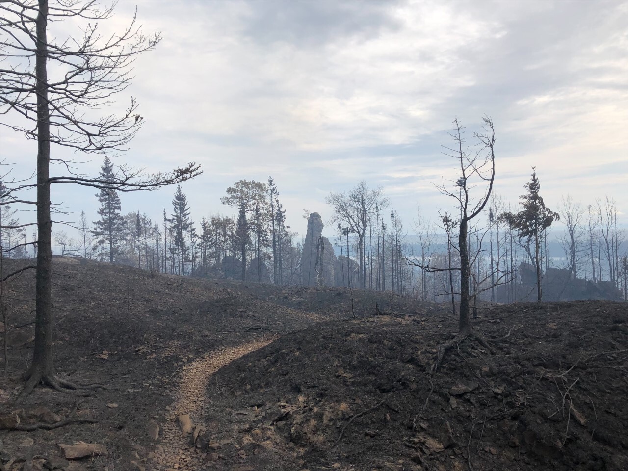
There's a bunch of new pics. The last is this pretty stark view of Monument Rock. Will have to try and get a shot from the same spot in a year or two to see the regrowth.
Re: Horne Fire
Posted: Thu Sep 02, 2021 2:53 pm
by johnhens
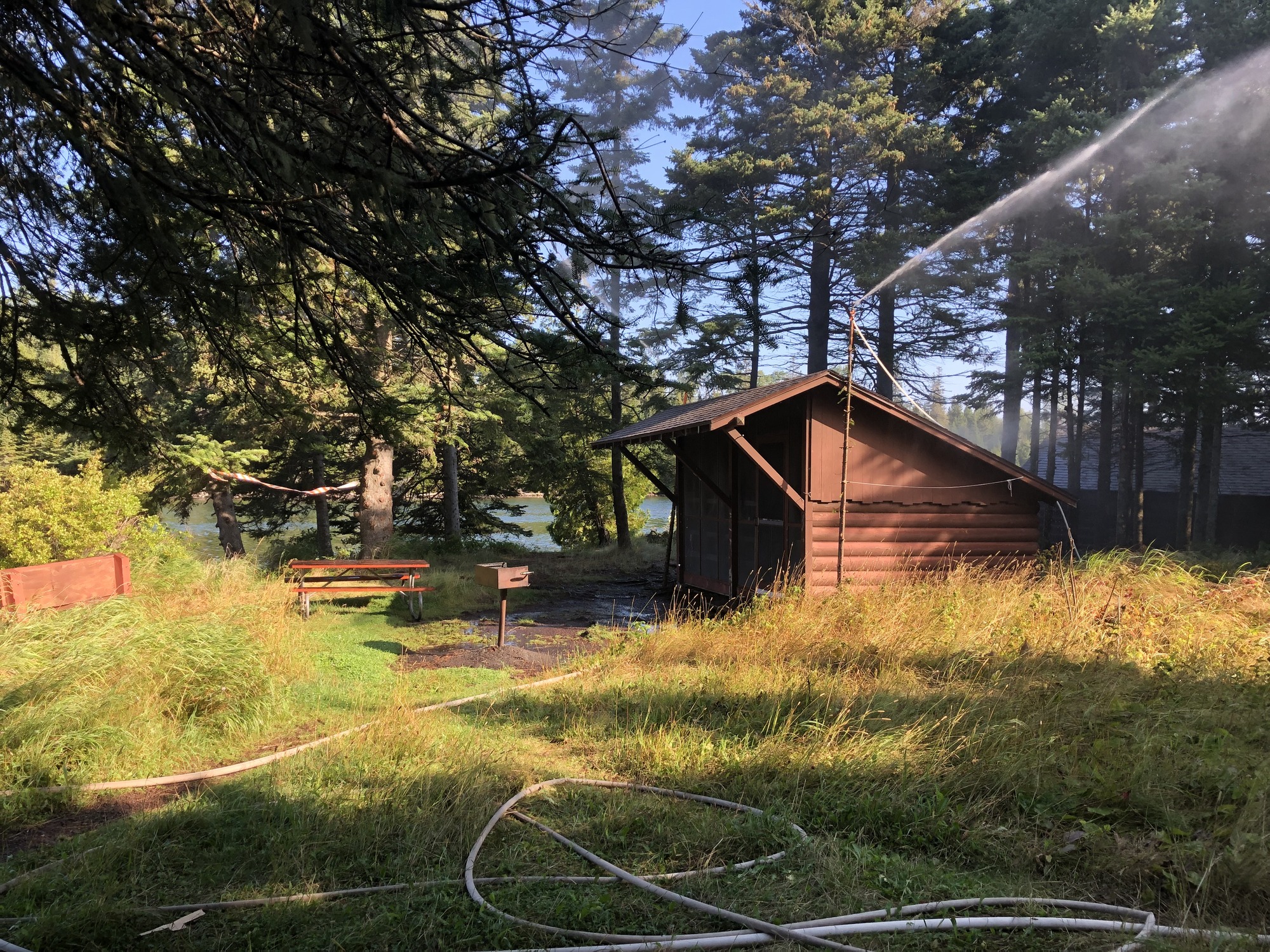
Sprinkler protecting Duncan Narrows shelter
Re: Horne Fire
Posted: Thu Sep 02, 2021 5:33 pm
by treeplanter
Amazing pics! Thanks for sharing. That's quite the view of Monument Rock. And I stayed at that Duncan Bay shelter many years back.
Re: Horne Fire
Posted: Thu Sep 02, 2021 5:42 pm
by treeplanter
Here's a link to a PDF of the Isle Royale Fire Plan. 128 pages:
http://npshistory.com/publications/isro/fmp-2004.pdf