Thanks all for some excellent advice.
treeplanter wrote: Mon Mar 18, 2019 9:14 am
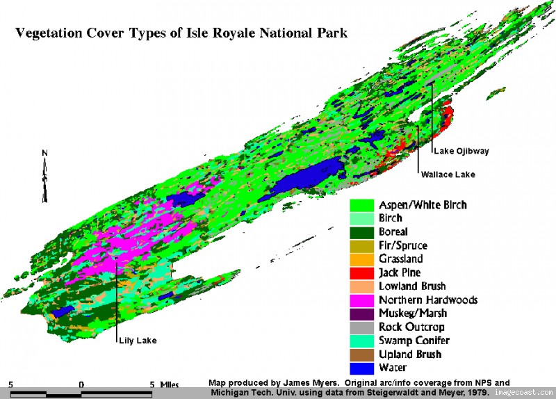
The vegetation map is good, but be aware that it shows overstory, not understory. All that balsam fir understory won't show on that map. But you can assume that if you find a aspen/birch overstory, it will have a balsam fir understory.
Ed's suggestion of starting from Chippewa Harbor is a good one. The 1936 burn covers a lot of the shoreline area from Chip to Saginaw Point, so the vegetation is still in the recovery stage (70-80 years later!). We did some off-trail hiking here years back and walking is relatively easy. There are still many rocky ridges that haven't grown back. With GPS, and a good compass and map, you could probably hike to Saginaw Point without many problems.
This is helpful -- hiking up the Indian Portage trail from Chippewa, I was impressed at how open the understory was in much of that area, probably due to the 1930's fire. Nothing near as dense as other parts of the island. I'm hopeful that some the forest south of Moskey might be this way. That said, your description and Midwest Ed's photos make me think that I'm just being wishful.
I wish I could do the suggested bushwhack from Chippewa Harbor east, but reaching Chippewa and then spending a day in the bush isn't reasonable for me this trip. That does sound like a fun hike though.
IncaRoads wrote: Mon Mar 18, 2019 10:12 am
In early season, a lot of the lower land like that at the end of Moskey Basin is quite saturated. The shoreline is un-walkable as the swampy lowlands extend right up to the big lake. I've had plenty of times where you take a step on the mud and go down 6-8 inches or more; there are some areas that are a bit marshy and you have no other choice but to move forward or take a big detour. A good pair of boots and gaitors are a must. I also wear a pair of gloves when hiking in the thick bush. You will be grabbing and hanging on to a lot of trees and branches.
I have heard that a reasonable route to Mt. Saginaw area is to head from the Moskey campground to the north shore of Wallace Lake, staying away from the Lake Superior shoreline where the density of the forest makes it tough walking. Keep on the highest ground possible and be prepared for wet areas not indicated on any map/photo. It is a very thick forest so take your time. Expect to do no better than 1 mile/hour as you will experience many detours around un-planned obstacles. Then head up the gully south of Newt Lake and then over to Mt. Saginaw, or to the high points to the west of Newt Lake. You may find rock outcroppings that present you with limited views.
That's what I was afraid of for the shoreline. But, thanks for the suggested route here. I may give it a try. I usually plan 1/2 mile/hr bushwhacking, so 1 mile per hour sounds like easy going.

The open ridgetops near Newt Lake look enticing to me, even if there's not too much to see. But it looks like I will need to be a bit more conservative in my planning and have some backups ready.