I'm planning a trip to ISRO on my boat this August. I was using Google Earth to scout out some anchorages. Google has acquired some more recent imagery (May 2009) since the last time I took a look at the island and I noticed something interesting.
If you look at the following sites, you might notice it too.
Rock Harbor
Daisy Farm
Moskey Basin
Chippewa Harbor
Wright Island
Siskiwit
Belle Isle
I've been to many of these places and did not notice anything while on the ground.
Did you find it?
Mystery
Moderator: srparr
-
Tom

- Forum Moderator
- Posts: 789
- Joined: Sun Feb 03, 2008 9:16 pm
- Isle Royale Visits: 16
- Location: Twin Cities, Minnesota
Re: Mystery
If you're referring to the alien landing sites, we're not supposed to talk about those... 
...Perhaps you could give us a small hint?
...Perhaps you could give us a small hint?
-
DonNewcomb

- IR Expert
- Posts: 522
- Joined: Mon Jul 20, 2009 6:48 am
- Isle Royale Visits: 1
- Location: Miss. Gulf Coast
-
Tampico

- May actually live on IR
- Posts: 311
- Joined: Tue Dec 08, 2009 10:59 pm
- Isle Royale Visits: 4
- Location: St. Paul, MN
- Been thanked: 1 time
Re: Mystery
Hint.
I've been to many of these places and did not notice anything white on the ground.
-
DonNewcomb
- IR Expert
- Posts: 522
- Joined: Mon Jul 20, 2009 6:48 am
- Isle Royale Visits: 1
- Location: Miss. Gulf Coast
Re: Mystery
I think it's the air-photo targets. I'm going to check on the USGS site and see if the orthophotos are available for download.Tom wrote:...Perhaps you could give us a small hint?
Here's http://www.blm.gov/or/gis/geoscience/aerial_faq.php some information from BLM. Scroll down to "Control Panels".
-
Tampico
- May actually live on IR
- Posts: 311
- Joined: Tue Dec 08, 2009 10:59 pm
- Isle Royale Visits: 4
- Location: St. Paul, MN
- Been thanked: 1 time
Re: Mystery
I missed the Windigo one. Thanks for the link/info Don.
I was sort-of hoping for some kind of gubment conspiracy...
I was sort-of hoping for some kind of gubment conspiracy...
-
Midwest Ed

- IR Expert
- Posts: 1397
- Joined: Sat Jul 03, 2010 2:25 am
- Isle Royale Visits: 8
- Location: Quad Cities, IL
- Has thanked: 24 times
- Been thanked: 28 times
- Contact:
Re: Mystery
These are the Control Panels at Daisy Farm, Rock Harbor and Belle Isle:
They are reflective targets that are manually placed to highlight either permanent USGS or temporary survey markers, in order to calibrate the location of the photos.
Daisy Farm
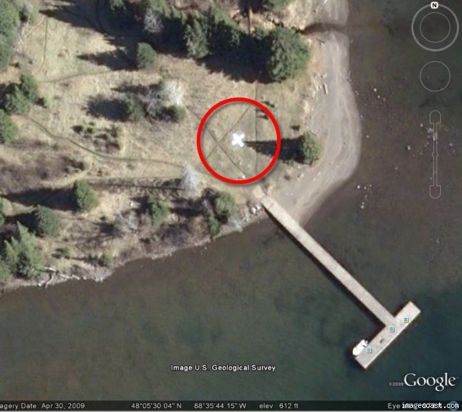
Rock Harbor
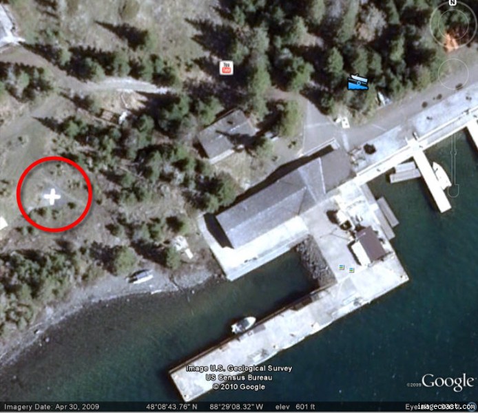
Belle Isle
They are reflective targets that are manually placed to highlight either permanent USGS or temporary survey markers, in order to calibrate the location of the photos.
Daisy Farm
Rock Harbor
Belle Isle
-
Pioneer Spirit

- NewbieCake
- Posts: 17
- Joined: Thu Jul 08, 2010 5:49 pm
- Isle Royale Visits: 0
- Location: McArthur, Ohio
- Contact:
Re: Mystery
I saw one painted in the middle of a country road in Ohio several years ago.
Live every day as if it was your last because one day you will be right.
-
fonixmunkee

- Forum Moderator
- Posts: 973
- Joined: Tue Sep 11, 2007 11:58 am
- Isle Royale Visits: 19
- Location: Soupe Towne, WI
- Has thanked: 9 times
- Been thanked: 20 times
Re: Mystery
I thought maybe they were part of the camera-taking apperatus to gauge or measure something within the photo itself, but it doesn't appear to be the case. If you scroll in and out of the sat images, the crosses resize larger or smaller.
Plus, it's ironic that they are all near a "developed" part of IR. Must of been put out by the NPS for something...surveying?
Plus, it's ironic that they are all near a "developed" part of IR. Must of been put out by the NPS for something...surveying?
-
DonNewcomb
- IR Expert
- Posts: 522
- Joined: Mon Jul 20, 2009 6:48 am
- Isle Royale Visits: 1
- Location: Miss. Gulf Coast
Re: Mystery
They are part of the process of photo interpretation. They are placed at known, surveyed, control points and allow the photogrammetrist to adjust the image to fit the spatial reference system. Once you have the known points "nailed down" you have a much better model of what is happening in between.fonixmunkee wrote: Must of been put out by the NPS for something...surveying?
-
Midwest Ed
- IR Expert
- Posts: 1397
- Joined: Sat Jul 03, 2010 2:25 am
- Isle Royale Visits: 8
- Location: Quad Cities, IL
- Has thanked: 24 times
- Been thanked: 28 times
- Contact:
Re: Mystery
The surveyed control "points" that Don describes actually look like this:

This one has not yet been stamped with its serial number and other survey information. After stamping, the location and elevation are recorded by the USGS (US Geologic Survey). Permanent USGS markers can be used to calibrate the photograph as Don described or sometimes 2 temporary markers are installed by surveyors. For the temporary units they sometimes only need to install them with a known distance separating them. The bright white markers are simply like big arrows pointing at these small markers.
This one has not yet been stamped with its serial number and other survey information. After stamping, the location and elevation are recorded by the USGS (US Geologic Survey). Permanent USGS markers can be used to calibrate the photograph as Don described or sometimes 2 temporary markers are installed by surveyors. For the temporary units they sometimes only need to install them with a known distance separating them. The bright white markers are simply like big arrows pointing at these small markers.
-
Tom
- Forum Moderator
- Posts: 789
- Joined: Sun Feb 03, 2008 9:16 pm
- Isle Royale Visits: 16
- Location: Twin Cities, Minnesota
Re: Mystery
In this case, I'm certain they're temporary markers, given they're out in the open/field areas. I guess I presumed they're mostly for aligning the overlapping flight runs.
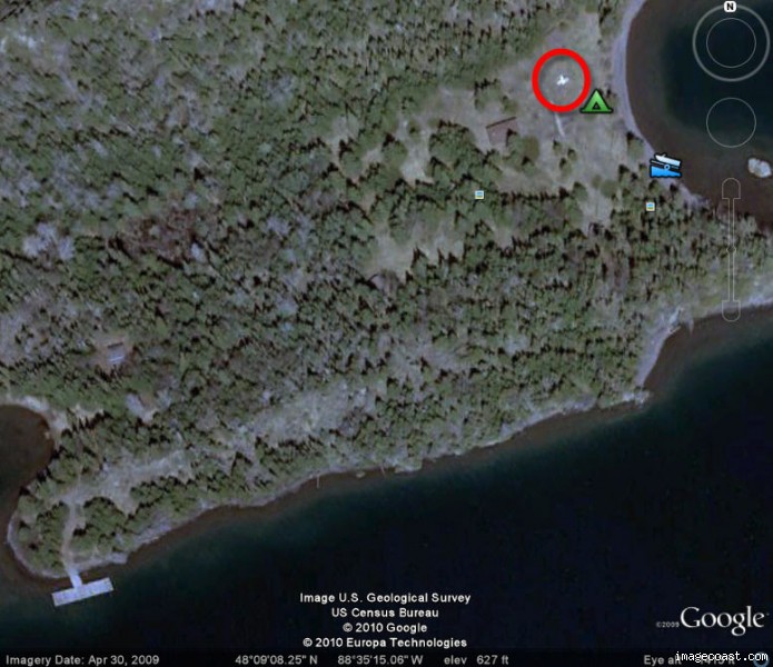
Here's one of the official markers, called "Falls" and is near Siskiwit Falls/Malone Bay.
Placed back in 1938, it's now in the middle of the woods, essentially. If you look at a Topo map, for instance the Trails Illustrated map from National Geographic, you'll find this one on the map as a small triangle with the elevation of 663 just west of camp. My understanding is that they were the triangulation points.
Here's one of the official markers, called "Falls" and is near Siskiwit Falls/Malone Bay.
-
DonNewcomb
- IR Expert
- Posts: 522
- Joined: Mon Jul 20, 2009 6:48 am
- Isle Royale Visits: 1
- Location: Miss. Gulf Coast
Re: Mystery
In this day and age, you drive a pin in the ground and collect GPS data over it for an hour and you have as good a benchmark as if you were over a brass disk.Tom wrote:In this case, I'm certain they're temporary markers,