Trail Difficulty

Questions about trails and campsites on the island.

Moderator: MikeT

Post Reply
sandystAR
NewbieCake
Posts: 25
Joined: Tue Jul 20, 2010 5:30 pm
Isle Royale Visits: 0
Location: Rogers, AR

Trail Difficulty

Post by sandystAR »

1st Trip to Isle Royale

Ok, I want you all to be honest. How difficult are some of these trails? I have been reading some of the posts and it just sounds like these trails have been so easy for a lot of people here and how quickly people can get to the campgrounds. I have been backpacking for a few years and I don't carry a heavy pack just because it isn't as much fun for me. I am not the fastest hiker so was just wondering.

Thanks. :)
Sandy
Northwest Arkansas
User avatar
emerysar
NewbieCake
Posts: 20
Joined: Sun Jul 18, 2010 7:45 pm
Isle Royale Visits: 2
Location: "The Thumb" of Michigan
Contact:

Re: Trail Difficulty

Post by emerysar »

Some trails are difficult. Depends on your physical ability, stamina, endurance, etc.

I'm nearly 30, and not in the best of shape (is round a shape? :shock: ), but with a carefully-weighed out pack (27 lbs.), lots of water, hiking poles, and no big rush to kill yourself each day, it was fine.

I went with a group of two others, who were in much better shape than I, and we all stayed at the same pace, stopping when we needed to for water, quick rests, photo ops, etc. At the end of the trail, they said I didn't slow down or speed up their usual pace at all.

After my second trip to I.R., I would probably change most of the hiking intensity levels in the guidebooks that say "easy" to "moderate". There wasn't any big "break-your-neck" type adventures that I've come across out there. The biggest challenges for me were not distance, but elevation (the "ups" were worse than the "downs"). I would say that my biggest challenges this year were going "uphill" from Windigo to Island Mine (most do it backwards coming from Rock Harbor, and have it as a downhill leg into Windigo). Another minor "toughie" was the West Hugginin Loop going from Minong up to Superior--less travelled and super "rooty" and bouldery in some spots.

I could safely lose 80-100 lbs., and I still did IR just fine.
sandystAR
NewbieCake
Posts: 25
Joined: Tue Jul 20, 2010 5:30 pm
Isle Royale Visits: 0
Location: Rogers, AR

Re: Trail Difficulty

Post by sandystAR »

emerysar - Thanks for your feedback. I am 52 years old and I guess a full-figured woman although I like the term voluptuous better (ha)! My pack will probably start out around 29-30 pounds (food). I won't hike without my poles. I always take plenty of water and am never in a hurry since I am a scenic hiker. :) I am staying on the east side so will be hiking those trails. I think I just need to believe in myself. :) I hike in NWA so I am used to tree roots, rocks and lots of ups and downs. I'll be sure and post when I return. Thanks again!
User avatar
emerysar
NewbieCake
Posts: 20
Joined: Sun Jul 18, 2010 7:45 pm
Isle Royale Visits: 2
Location: "The Thumb" of Michigan
Contact:

Re: Trail Difficulty

Post by emerysar »

You'll do just fine. I've posted the results of our trip (last week) on the log page. It links to my website if you'd like to see more-- 75 pics + a video of the moose and calf coming through our campsite in Washington Creek!

http://www.chasingthenortherndream.com (It is the first posting for August 2010)

Enjoy your trip to IRSO! You'll be hooked! :)
MissMoose
NewbieCake
Posts: 2
Joined: Wed Jul 28, 2010 3:29 pm
Isle Royale Visits: 1
Location: Nebraska

Re: Trail Difficulty

Post by MissMoose »

Sandy,
June 2010 was my first backpacking trip. I'm 5'4, 57 years old and need to lose about 30 pounds. I don't know how heavy my pack was but I wasn't able to make it to Huginin Cove from Windigo. We stayed at Washington Creek. I think I could have made it without the heavy backpack, will plan better next time. I love hiking and will need to work into the weight of a backpack or stay at Rock Harbor Lodge and take day hikes. There is a book on Isle Royale that I read which went into detail on the trails, it's worth reading.

I admire you for taking such a wonderful adventure on your own.
Mary Jane
jerry
IR Expert
Posts: 541
Joined: Mon Jun 22, 2009 6:52 pm
Isle Royale Visits: 14
Location: Dayton, Ohio

Re: Trail Difficulty

Post by jerry »

I solo hiked the west end, the east end and the middle in years '06 thru '09. I'm 66, I think you'll do fine. jerry
sandystAR
NewbieCake
Posts: 25
Joined: Tue Jul 20, 2010 5:30 pm
Isle Royale Visits: 0
Location: Rogers, AR

Re: Trail Difficulty

Post by sandystAR »

Thanks everyone for sharing all of your experiences with me. I am really looking forward to my trip.

To be honest with you all, I have no idea how this all happened. I was hiking with a friend (learning some basic orienteering skills) back in February. We were talking about cool vacation places and I heard the words Isle Royale come out of my mouth. I have NO idea where that came from and now here I am with maps and books in hand, a ferry ticket and an Isle Royale forum member.

Again, I appreciate all of your suggestions and comments. :)
Sandy
Northwest Arkansas
jerry
IR Expert
Posts: 541
Joined: Mon Jun 22, 2009 6:52 pm
Isle Royale Visits: 14
Location: Dayton, Ohio

Re: Trail Difficulty

Post by jerry »

You'll be sorry (I remember saying that to the new guys when I was being discharged from the Army). You'll probably get hooked and want to go back and back and back, etc. This is better then the Army ever could be.
User avatar
Midwest Ed
IR Expert
Posts: 1363
Joined: Sat Jul 03, 2010 2:25 am
Isle Royale Visits: 8
Location: Quad Cities, IL

Re: Trail Difficulty

Post by Midwest Ed »

The most difficult aspects of some trails is that they will tire you out with sections of repeated up and down. Five feet up. Ten feet down. Twenty feet up. Five feet down. These types of trails are among those that generally run longitudinally along the general lengthwise dimension of the island, especially the trails closer to the Lake Superior shore. The Rock Harbor Trail from Three Mile to Moskey Basin is a good example (although the location of this trail has been moved over the years). The old hiking adage of finding and maintaining the high ground can sometimes be challenging. Another difficult aspect of walking other than the rocky footing is the sometimes numerous exposed tree roots. Not terribly difficult but can be made worse when wet, but again the only real danger is a twisted ankle. Stay on the trails and there is almost no risk from falling a dangerous distance.

Hike crosswise across the island and you find yourself going up and down larger elevations as there are many ridges and valleys to cross. But the average ridge to valley elevation difference is only a few hundred feet. The highest point on the island is only about 800 feet above Lake Superior. The main and highest ridge averages about 600 feet above the big lake. There are some high and shear cliffs to the north that should be avoided (avoid the cliffs not the beautiful views). The trails do not take you close to any areas where there is a danger of falling. This risk aspect is much easier and safer than you would encounter in many areas like the Rockies or other mountainous areas.

During the very early part of the season (May), before trail maintenance crews have gotten to work, you will have to climb over or crawl under a few dead falls that have blocked the trail. Also, after heavy rains your boots will get muddy and your feet will get wet in the valley regions (take extra socks). The very worst and swampy areas have man made boardwalks to get you through and keep you dry. You should hopefully never have to wade through water except for maybe parts of the Minong trail. I have never been on that section south of Little Todd Harbor and I’ve heard that it is the harshest of the trails.

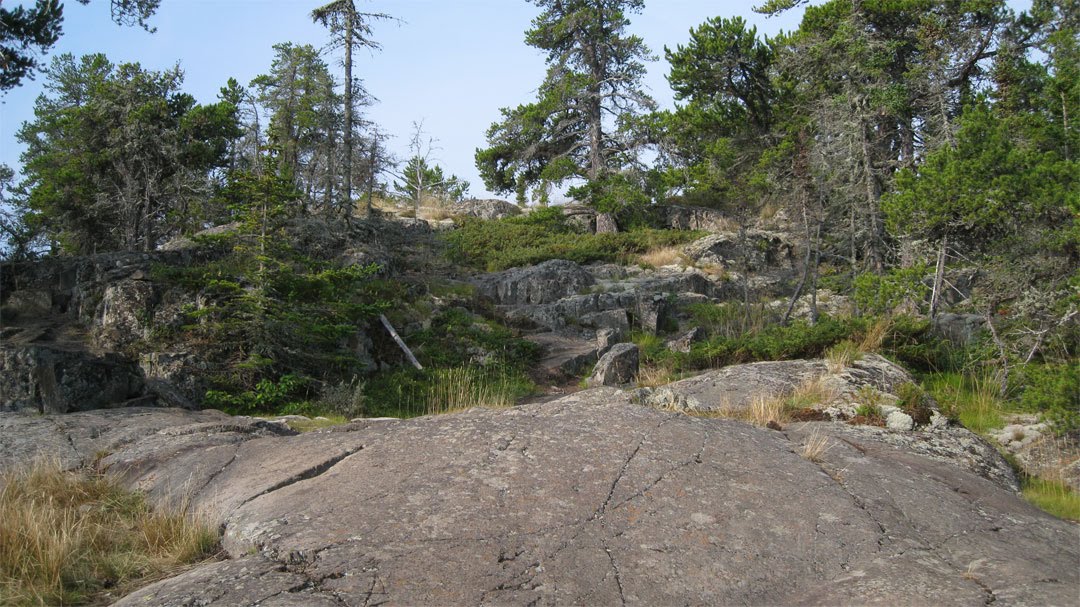
There are many many places where you are simply taking a casual stroll in the woods along a very flat and stable trail surface. Other places along ridges you will be walking over long sections of fairly flat yet rolling rock that is among some of the oldest on Earth. Some of these ridge crests are barren of soil and trees to the extent that you might temporarily lose the trail if you are not paying close attention to the rock cairns.

Being a scenic hiker, you will have a wonderful time. You will travel through several types of forest from boreal evergreen to hardwood to birch and aspen. The geology is extremely interesting as well. Since there are no bears the only animals you will have to fear are the squirrels, so tame I have had them run up my pant leg (on the outside thankfully). But don’t turn your back on them as they will quickly chew through your pack to find that trail mix. The birds (especially Canada Jays) will eat from your hand. Also, never take your eyes off your boots or a campground fox may quickly run off with one.

Have a great time and please stop back here when you get home, hopefully with some pictures.

~Ed

p.s. Here's a picture of the lake shore trail to Moskey Basin, borrowed from BlackCoffee's blog.

http://www.blackcoffeeatsunrise.com/200 ... three.html

Image
Last edited by Midwest Ed on Tue Aug 10, 2010 10:42 pm, edited 2 times in total.
8 trips, 1975 x 2, 1976 x 2, 1978, 1985, 2000, 2013
robin621
LNT Expert
Posts: 75
Joined: Tue Jan 05, 2010 6:14 pm
Isle Royale Visits: 5
Location: Phoenix, AZ

Re: Trail Difficulty

Post by robin621 »

It depends on your physical condition, pack weight and if you're portaging. I worked out hardcore for 4 months before trip (I even hiked moutains in 100 degree weather with my back preparing myself for IR). IR still beat me up a little. The better shape you are in the better the trip. However, when I was catching lots of pike I kind of forget about how sore my muscles were.
johnhens
Forum Moderator
Posts: 1993
Joined: Wed Oct 03, 2007 5:10 pm
Isle Royale Visits: 34
Location: Big Rock, IL

Re: Trail Difficulty

Post by johnhens »

As others have stated the "roots and rocks" are the big problem. You need to keep focused on where you are stepping. It is easy to turn an ankle particularly after rain when the smooth rocks are slippery and the trail is muddy. The pungeons/boardwalks can be 'exciting' in the AM if there was a frost the night before and/or they are wet.
The ups and downs are tiring particularly where the up or down is a big step.
If you don't use them, consider hiking poles as they offer somewhat of a third leg to balance on.
Above all don't be intimidated by what read you read here and elsewhere, the trails are within mosts normal walking ability.
Take your time and don't forget to admire the flora and fauna of the Island.
sandystAR
NewbieCake
Posts: 25
Joined: Tue Jul 20, 2010 5:30 pm
Isle Royale Visits: 0
Location: Rogers, AR

Re: Trail Difficulty

Post by sandystAR »

johnhens - Thanks for your information. I have hiked parts of the Ozark Highlands trail and the tree roots and rocks pretty much make up the OHT. Thanks for the heads up on the boardwalks. That's like walking on the wet leaves on the OHT...slippery! I do have poles and definitely will be brining them with me.

robin621 - Yeah, no pain no gain right? :) I haven't been training as long as you did, but I work for an outdoor retail center and am moving up and down stairs all day. That is helping a little. I have been doing some hikes with my pack up and down hills and trails to get used to my pack. But I am sure I will feel as you do after seeing the views, setting up camp and just being.

Midwest Ed - Thanks for your very thorough answers to my questions along with the photo. Your information and suggestions have been extremely helpful. Thanks so much!

:)
Sandy
goatrodeo2010
NewbieCake
Posts: 12
Joined: Sun Apr 25, 2010 8:46 am

Re: Trail Difficulty

Post by goatrodeo2010 »

Sandy, trails are rooted, rocky and up and down - but you'll have a blast. Did 8 days and the first two kicked my butt, then it was better each day from there. 5' 10" at 210# I had a lot of fun even with 50+ in my pack, I just kept thinking it was "mind over matter". Take your time and smell the roses, per say. We seem to rush to put out the fire each day and I now wish that I would have stopped and smelled the roses. Never did see that fire, so don't rush to get there. Have a great hike!
sandystAR
NewbieCake
Posts: 25
Joined: Tue Jul 20, 2010 5:30 pm
Isle Royale Visits: 0
Location: Rogers, AR

Re: Trail Difficulty

Post by sandystAR »

goatrodeo2010 - Great pearls of wisdom! Thank you!

Sandy
Post Reply