Route Dilemma, Can You Solve It?

Questions about trails and campsites on the island.

Moderator: MikeT

Post Reply
User avatar
Rafiki
IR Expert
Posts: 541
Joined: Thu Apr 08, 2010 11:11 am
Isle Royale Visits: 7
Location: Chicago, IL

Route Dilemma, Can You Solve It?

Post by Rafiki »

Image

Here is my dilemma. Above you will find a image of the Isle Royale Map. The parts of the trail that are highlighted in blue are the parts that I have not hiked yet. I would like try to hike as much of the blue as possible, if not all of it, within two more trips (each trip being up to 2 weeks long.) Here are some key points keep to keep in mind as you devise a plan for the two trips.

- I'd prefer to take either the Isle Queen IV or Ranger III instead of having to travel to Minnesota to ride the Voyageur (unless you have the best idea ever using the Voyageur.)

- I do not mind using the Voyageur as a means of inner-island travel once during each trip. Therefore, if you are unfamiliar with this option, the Voyageur would allow me to travel from Windigo to McCargoe or Rock Harbor OR it would allow me to travel from McCargoe to Rock Harbor with regards to the north side of the island. The Voyageur would also allow me to travel from Rock Harbor to Daisy Farm or Malone Bay or Windigo OR it would allow me to travel from Daisy Farm to Malone Bay or Windigo OR it would allow me to travel from Malone Bay to Windigo. (At most, I would only want to use this option once per trip because it would cost me $47-$59.)

- If I ever hike to Malone Bay, I definitely want to have the Voyageur take me to Windigo so I do not have to rehike the 7 miles to leave this area.

Let the brainstorming begin. Thanks guys!
343.1 Miles Hiked: 2004 (3 Days), 2010 (11 Days), 2011 (13 Days), 2012 X 2 (8 + 12 Days), 2013 (9 Days/Paddling), 2019 (30 Days/Paddling)
jerry
IR Expert
Posts: 541
Joined: Mon Jun 22, 2009 5:52 pm
Isle Royale Visits: 14
Location: Dayton, Ohio
Has thanked: 2 times
Been thanked: 19 times

Re: Route Dilemma, Can You Solve It?

Post by jerry »

Don't forget when budgeting for your use of the Voyaguer that they also have a fuel surcharge. (I really have enjoyed my trips on the V2, try using it from Minnesota.)

What's the maximum miles that you can hike in one day?
User avatar
Ingo
Forum Moderator
Posts: 1959
Joined: Wed Sep 12, 2007 1:11 pm
Isle Royale Visits: 14
Location: Hillsborough, NC
Has thanked: 288 times
Been thanked: 181 times

Re: Route Dilemma, Can You Solve It?

Post by Ingo »

I may be the least authority (I paddle, don't backpack), but here's what I see:

Trip 1: Take the new boat (1.5 hr trip) to Windigo, yeh I know...
Feldtmann Loop to Island Mine
Greenstone to Hatchet Lake
Cut over to Minong
Minong to Windigo
At beginning or end, hike the Greenstone from Windigo to Island Mine (and back). Maybe a day hike??

Trip 2: Boat to Rock Harbor.
Voyageur II to Malone Bay.
Up to the Greenstone, head back to Rock Harbor with side trips to McCargoe and Daisy Farm along the way. Some backtracking, but not too much.
From Lane Cove you could day hike to Lookout Louise and Hidden Lake. Problem with other options I can think of is that R.H. and Three Mile have 1 night limits, unless you're early or late in the season.
22: BI-PC-BI-RH, 21: RH-ML-DF-MB-DF, 18: MC-PC-BI-DB-RH-DF, 17: WI-IM-SB-FL-WC, 16: RH-CI-TI-RH, 14: BI-ML-CI-CH-MB, 13: RH-PI, 12: MC-CB-HL-TH, 11: WC-HC-WC, 09: MC-BI-DN-RH, 05: MI-CI-MB-DF-RH-TM-RH, 02: MC-LR-WL-CH, 01: BI-DB-RH, 79: worked RH
User avatar
Rafiki
IR Expert
Posts: 541
Joined: Thu Apr 08, 2010 11:11 am
Isle Royale Visits: 7
Location: Chicago, IL

Re: Route Dilemma, Can You Solve It?

Post by Rafiki »

Jerry:

I did not know there was a fuel surcharge. Thanks for the heads up on this matter. How much extra does the fuel surcharge hike up the price?

As far as miles per day are concerned, it should be noted that I will be doing this trip with my girlfriend. With that known, we would like to limit on our distances to about 6-9 miles per day for the first week while are packs are full. However, during the second week, we do not mind doing distances between 9-15 miles per day when necessary. On the last day of our last trip, we walked from Chippewa Harbor to Rock Harbor (17 miles) without much difficulty due to the lack of weight in our backpacks.


Ingo:

It should be noted that we will probably be going on our trip during the last week in August or in Early September. Therefore, the limits set on certain camp sites probably won't be in effect.

As far as your plan is concerned, I very much like the idea you have going on with Trip 1 with the exception of having to drive to Minnesota to take the Voyageur. To remedy this problem, I was thinking that I could do the following but realized I had an issue with my solution once I got to the end of my Trip 1:

Trip 1:
Take Ranger or Isle Queen to Rock Harbor and hike to Lane Cove.
Hike Lane Cove to Daisy Farm.
Take Voyageur from Daisy Farm to Windigo and hike to Feldtmann Loop over a couple of days.
Go from Island Mine on the Greenstone to the cut over at Hatchet Lake
Take the Minong back to Windigo
PROBLEM: Id have to take the Voyageur back to Rock Harbor and that would be two inter-island travels when I told myself I would only limit myself to one per trip.

Any further thoughts?

As far as trip 2 was concerned, I did not like the idea of taking a Ferry over to Rock Harbor and wasting a whole day to wait for the Voyageur to take us to Malone on the following day.

Any further thoughts?
Last edited by Rafiki on Tue Mar 22, 2011 7:43 pm, edited 1 time in total.
343.1 Miles Hiked: 2004 (3 Days), 2010 (11 Days), 2011 (13 Days), 2012 X 2 (8 + 12 Days), 2013 (9 Days/Paddling), 2019 (30 Days/Paddling)
User avatar
Nick
Bushwacker
Posts: 242
Joined: Fri Feb 15, 2008 6:57 am
Isle Royale Visits: 23
Location: DeTour Village, mi
Been thanked: 6 times

Re: Route Dilemma, Can You Solve It?

Post by Nick »

What's the hurry. I just wrapped up all the trails on the Island in 2009 and it only took me 33 years!

Route 1: Ranger or Queen to Rock. Hike to 3 Mile, doing those spurs along the way. Then base out of 3 Mile and day hike to Hidden Lake. I did it easily in a day and I was 55 at the time. If you are really energetic, catch the spur down to Lane Cove. Then up the Greenstone to McCargo and loop back via Daisy Farm. Easily done in less then a week, so take your time.

West end might be more problematic. That spur down to Malone is just plain long. And, it might be tough to pick up the trail to Malone because it is not heavily traveled. Last time I was there, I had trouble finding it from the Greenstone. I'd start in Windigo. Do the Feldman loop via Island mine. The Voyaguer can get you there by 10 a.m. and you can make Siskwit Bay easily by day 1. Then go to Feldtman Lake on Day 2. Day 3 back to Windigo. Day 4 to South Desor. Day 6 is a day hike from Desor to Malone and back. Travel light. Day 7 to Hatchet or even Big Todd Harbor. Day 8 to North Desor. Day 9 to Windigo. Rest and Relax. Day 11 or 12 do a Day hike on the Hugginin Cove Loop. Done.

Or, take another 15 or 20 years and really enjoy the island.
User avatar
Rafiki
IR Expert
Posts: 541
Joined: Thu Apr 08, 2010 11:11 am
Isle Royale Visits: 7
Location: Chicago, IL

Re: Route Dilemma, Can You Solve It?

Post by Rafiki »

1st Reply to Nick:

Your reply seemed to have been cut-off when I originally read it at, "catch the spur down do..." However, I am going to read where it seems have magically picked up at after I make my first reply and write another reply afterwards. It was weird, cause I refreshed the screen a couple of times before I made my first reply to see if something was wrong with my computer. This was my first reply to you:

As far as wanting to get it done with all of the trails so quickly, I blame this fact on the enjoyment and satisfaction I get out of hiking heavy miles. If I were not going with my girlfriend, I would want to do 20 miles each day. I consider myself to be in decent shape with an ultra-light (or as light as possible) mentality and do not like sitting around. Sunlight means hiking to me, and if I'm not on the trail during the day, I feel as though time is wasting away when there is so much to see. Granted, sometimes there are many things to be seen just sitting around camp.

Regardless, I am going with my girlfriend, so it would not be fair to impose my normal ambitions upon her. I realized last trip that when we have full packs, 6-9 miles was ideal for her and when we had partially loaded packs 9-15 miles was something that she was to conquer without much difficulty.

Therefore, to draw a comprise between our physical abilities, we hike miles that work best for her and set extra time aside to achieve the distances that satisfy my cravings. Furthermore, the sooner we are able to observe the island in its entirety, the quicker we will be able to select our favorite sites. Right now McCargoe Cove and Moskey are our two favorites. Once we have established a general idea of where we like visiting, we can aim at doing annuals trips to the island that allow us to see the places that we most appreciate while avoiding some of the ones we find lack luster.

I know you may have a different opinion on matters and how the island should be witnessed, but for me, as pathetic as this may sound, I get a high off of knowing that I did "X" amount of miles during a certain trip and was able to observe a variety of terrains.

2nd reply to Nick:

The first idea you have sounds good, but I do not like how the first trip is only centered around the east side of the island. I feel as though that since I do not have much to cover on the east side, dedicating one trip to finishing it is not time efficient. It would be nice to stay at Lane Cove for a night, but would rather skip staying at Daisy Farm or Three Mile if possible unless my final plan requires me to stay at Daisy Farm to catch the Voyageur for an inter-island transfer.

You seem to be on to something with your second idea. Except you have me start in Windigo without stating how I am to get there in the first place. As I have hinted, if I can avoid traveling to Grand Portage, MN to take the Voyageur over to Windigo, I would like to do so. Continuing on with what I stated about Malone Bay, if I decide to hike to this location, I'd really prefer not to have to back track the 7 miles to leave this area. I'd much rather just have the Voyageur haul me out of there back to Windigo.

I realize you may be shaking your head now saying that I am asking for an impossible plan with all of the restrictions I am putting into place. However, as hard as my requirements may appear to be work aroundable, I am hoping that someone on here can still be crafty enough to help me figure out an itinerary that is close to ideal, if not perfect.
343.1 Miles Hiked: 2004 (3 Days), 2010 (11 Days), 2011 (13 Days), 2012 X 2 (8 + 12 Days), 2013 (9 Days/Paddling), 2019 (30 Days/Paddling)
jerry
IR Expert
Posts: 541
Joined: Mon Jun 22, 2009 5:52 pm
Isle Royale Visits: 14
Location: Dayton, Ohio
Has thanked: 2 times
Been thanked: 19 times

Re: Route Dilemma, Can You Solve It?

Post by jerry »

I see no mention of the plane that could take you from Rock Harbor to Windigo or Windigo to Rock Harbor.

The fuel surcharge on the V2 is $4 one way from Minn. to Windigo, $8 one way if you go from Minn. to points beyond Windigo (such as McCargoe, Belle Is. or Rock Harbor). The surcharge one way might be $4 from Daisy Farm to Windigo or Malone (I think). These are listed near the end of the rates that are given at the web site.
User avatar
Ingo
Forum Moderator
Posts: 1959
Joined: Wed Sep 12, 2007 1:11 pm
Isle Royale Visits: 14
Location: Hillsborough, NC
Has thanked: 288 times
Been thanked: 181 times

Re: Route Dilemma, Can You Solve It?

Post by Ingo »

Rafiki wrote:Ingo:
As far as your plan is concerned, I very much like the idea you have going on with Trip 1 with the exception of having to drive to Minnesota to take the Voyageur.
Seems to me like you're going to have to comprise somewhere :). And the drive along the North Shore of Superior is pretty nice :D (both MN or Ontario). There is the seaplane option too, which can deliver you to/from Windigo. More $$$ obviously, but maybe not if you account for extra travel miles/nights.
Rafiki wrote:As far as trip 2 was concerned, I did not like the idea of taking a Ferry over to Rock Harbor and wasting a whole day to wait for the Voyageur to take us to Malone on the following day.
Get the hike to Scoville Point in. That's good for a couple hours. And/or rent a canoe and do Tobin Harbor by water. If you take the Ranger it's less than 1/2 day to kill, somewhat more for the Queen.

Unless you want to hike the island pretty much end to end twice, I don't see how you can avoid Minnesota and/or the Voyegeur.
22: BI-PC-BI-RH, 21: RH-ML-DF-MB-DF, 18: MC-PC-BI-DB-RH-DF, 17: WI-IM-SB-FL-WC, 16: RH-CI-TI-RH, 14: BI-ML-CI-CH-MB, 13: RH-PI, 12: MC-CB-HL-TH, 11: WC-HC-WC, 09: MC-BI-DN-RH, 05: MI-CI-MB-DF-RH-TM-RH, 02: MC-LR-WL-CH, 01: BI-DB-RH, 79: worked RH
User avatar
Rafiki
IR Expert
Posts: 541
Joined: Thu Apr 08, 2010 11:11 am
Isle Royale Visits: 7
Location: Chicago, IL

Re: Route Dilemma, Can You Solve It?

Post by Rafiki »

As I said, and as you have already gone on to re-hint, perhaps I am/was asking for the impossible. Therefore, I have made some sacrifices to my original agenda restrictions and have come up with the following:

Trip 1:

Take Isle Queen or Ranger to Rock Harbor hike to Lane Cove.
Lane Cove to McCargoe (only day my girlfriend probably won't like.)
McCargoe to Hatchet
Hatchet to Malone Bay
Malone Bay to South Desor
South Desor to Windigo
Take Ferry to McCargoe hike to Moskey
Moskey to Roch Harbor and come home.

We both love McCargoe and Moskey, so trip one covers our favorite sites. Trip one also allows us to hit up many areas we haven't visited before. The two negative things about trip one is that we have to hike in and out of Malone Bay and overlap over the 7 mile path to get to Malone Bay. Going to Lane Cove to McCargoe on our second day will not be something my girlfriend will be thrilled about. Thankfully if we take an extra day at McCargoe, I believe this will allow her to recover her strength. Outside of this, I guess I will just have to stuck it up when it comes to backtracking our way out of Malone Bay.

Trip 2

Ideally take the Voyageur to McCargoe Cove.
Work our way along the Minong going west until we get to Windigo.
Do the Feldtmenn lake loop and return to Windigo
Return back home on the Voyageur.

This would be the ideal Trip 2. However, what we will really probably do is take the Isle Queen or Ranger to Rock Harbor, Hike to McCargoe, and work the rest of the plan from there. Then once we get to windigo, have the Voyageur take us back to Rock Harbor at to which point we'll do some of the small trails before we are picked up the following morning by the Isle Queen or Ranger.

The reason I have an issue with taking the Voyageur is because the trip as a whole ends up costing us about an extra $125 each or $250 collectively. Call me frugal, but that's a lot of dough. The reason it costs extra is based on gas that it takes to get there and get back, the hotel rates of the Casino place which appears to be the only close place to the Grand Portage Harbor, Voyageur rates themselves, parking fees, and something else that is not coming to my head now. However, I did not calculate the inter-island ferry ride costs in my other two scenrios when it comes to not using the Voyageur to get to the island itself. Therefore, if we are to figure those fees into the other two options (Isle Queen and Ranger) and the prices they run, technically it would only cost us an extra $65 each or $130 collectively. $130 is still $130, but even with that aside, its also the difference between driving 7.5 hours and 10.5 hours :/

Sorry for my long-windedness, not sure if you really cared for me to go into that extreme amount of detail, but I figured I'd try to emphasize where I am coming from as best as I can. Furthermore, the sea plane is not an option for obvious reasons :) If you or anyone else has any other suggestions, I do not plan on making my trip over to the island until fall, so I would be very eager to hear of any ideas that anyone feels like sharing. Thanks.
343.1 Miles Hiked: 2004 (3 Days), 2010 (11 Days), 2011 (13 Days), 2012 X 2 (8 + 12 Days), 2013 (9 Days/Paddling), 2019 (30 Days/Paddling)
User avatar
Tom
Forum Moderator
Posts: 789
Joined: Sun Feb 03, 2008 9:16 pm
Isle Royale Visits: 16
Location: Twin Cities, Minnesota
Been thanked: 12 times

Re: Route Dilemma, Can You Solve It?

Post by Tom »

Alrighty, I'll take a shot Rafiki. (Or should we call you "Grafiki?" :P )

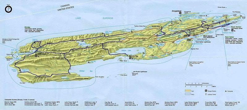
Here's my proposal! Mileages are for mileage with a pack on, and distances taken from the mileage chart found on the forum. (Except for Lane Cove to McCargoe; the chart indicates 22.4, and it's probably 12.4..)
I didn't match it to ferry schedules, but I'm guessing you'll work that out...

Parameters: Arrive and Depart at Rock Harbor; allow for one intra-island ferry per trip; up to two weeks on Island per trip, strive for no more than 9 miles per day in first week of journey. (*That is more difficult on the West side, where camps are more distant, but I kept it close as possible.)


Trip 1:
1. Ferry to Rock Harbor. Day hike to Scoville point, get in those trails. Spend night at RH.
2. Voyageur II from RH to Malone. Get off ferry, begin the lovely hike up to Desor S. (10.8mi) The first half is
fairly level and follows the lake, the second half to the tower is up, then you're good.

3. Desor South to Siskiwit Bay (9.9mi) In the trees until Island Mine, and then down to the bay.
4. Siskiwit Bay to Feldtman. (10.2mi) Hike down to Rainbow Cove after setting up camp. Up and over the ridge, but a
health day's hike.

5. Feldtman to Windigo/Washington Creek. (9.1mi) Pretty typical Isle Royale for the next couple days..
6. Washington Creek to Hugginin. Take Eastern loop. (4.2mi) (Rest day)
7. Hugginin Cove to Island Mine. Take Western loop of Hugginin Trail. (10.0mi) Sorry about the uphill, but it's not
horrible..

8. Island Mine to Hatchet. (12.8mi) (Your first official backtracking from Island Mine to Ishpeming Tower) It's a
longer day, but you're up on the ridge for the most part, with not too much up and down at this stretch.

9. Hatchet to Chickenbone West. (7.9mi) Yay! You get to go DOWN off the ridge, instead of the other way!
10. Chickenbone West to Daisy Farm. (7.9mi) Set camp and hike the "triangle" without packs, or at least to Tower and
back via Mt Ojibway Trail. Classic Isle Royale Greenstone hiking.
11. Daisy Farm to Rock Harbor, cut over at Threemile and hike Tobin trail. (7.7mi) Catch Ferry off island. The Tobin
Harbor trail is fast and easy. Just wake up early, depending on your boat.


Trip 2:
1. Ferry to Rock Harbor. Hike to Threemile. (2.7mi) What an easy start!
2. Base at Threemile, presuming 'off peak' season. Dayhike to Hidden lake/Lookout Louise on Greenstone and back.
3. Threemile to Lane Cove. (4.6mi) Up and over. Just try not to think about the return out of Lane Cove just yet.
4. Lane Cove to McCargoe Cove via East Chickenbone trail. (12.4mi) As you indicate, it would be a long day, but take
your time.

5. McCargoe Cove to Todd Harbor. (6.6mi) The easiest stretch of the Minong, IMHO.
6. Todd Harbor to Little Todd. (6.7mi) Only one or two ugly water crossings, if water is high. Otherwise, a great
hike.

7. Little Todd to Desor North. (5.7mi) A gorgeous section of trail, albeit slow, mainly because you need to watch foot placement.
8. Desor North to Washington Creek. (12.6mi) Up/Down. Up/Down. Up/Down. Repeat. Like x18.
9. Take Voyageur II to Rock Harbor. Set back and enjoy looking at the ridge you just crossed from the lake view!
10. Ferry to Mainland!
Post Reply