First time to IR. Wife and I have done hiking before - we're still in the novice category but not in the newbies. We have a good (lightweight) collection of gear. My pack will likely be around 40 lbs, her's around 30 and the kids around 15 to 10. We did 15 miles last summer in the Smokey Mountains... looking for any feedback on the route.
Day 1: Arrive at Rock Harbor and stay night (there may be ranger programs or canoe that we can do to Rasberry island?)
Day 2: Voyager II to Chippewa Harbor then hike to Lake Richie for night (5.4 miles)
Day 3: Hike to one of three deestination - (around 6 miles)...
- East Chickenbone Lake
- Daisy Farm
- Lake Mahone
Day 4: Hike (or stay over) at Daiy Farm (0 to 8 miles)...
Day 5: Hike to Three Mile (4.4 miles)
Day 6: Hike to Rock Harbor (3.6 miles) and take Queen 4 back to Cooper Harbor in afternoon.
Q1: Day 3... we were going to play it by ear to see which site to go with. From reports, sounds like E.Chickenbone is a pain for getting water but Lake Mahone adds another 1+ miles to hiking. Daisy Farm lets us lounge for a whole day at one spot though we see less of the island. Recommendation? Is Lake Mahone worth it or Daisy Farm worth 2 days?
Q2: Tower that is north of Daisy Farm... worth it to hike up to as a day hike or walking by from East Chickenbone or skip it?
Q3: Not on the route... but, what do you tenters do about Food storage? Sounds like vermin get into hanging bags but I don't want the rodents chewing through our tent to get to the goodies...
Thanks!
Itinerary - Late July to Early August
Moderator: MikeT
-
Ingo

- Forum Moderator
- Posts: 2023
- Joined: Wed Sep 12, 2007 2:11 pm
- Isle Royale Visits: 15
- Location: Hillsborough, NC
- Has thanked: 73 times
- Been thanked: 64 times
Re: Itinerary - Late July to Early August
Welcome to the forums and the island! The thing to remember is that are really no "bad" places to go or stay, although folks have their preferences. Also, your itinerary is not fixed, so you can change your mind based on how everyone is doing. That said:
Day 1: Yes, there's usually a ranger program, although I'm not positive it is every night. Paddling to Raspberry Island is pretty open water, so not sure I'd recommend it, unless all of you (including kids) are experienced in a canoe. That's also weather dependent of course. You can rent canoes on either the R.H. side or the Tobin Harbor side which is more protected. But I'd suggest the hike out to Scoville Point--it's beautiful and good warmup, about 4 miles round trip (without packs ).
).
Day 3: I think you may have confused "Lake Mahone" with either McCargoe Cove or Moskey Basin? In any case, Moskey Basin is a perennial favorite with most folks. If you went from Richie to Moskey, it would almost be like a layover day (2+ miles).
East Chickenbone is pretty unanimously considered the "worst" campground on the island. McCargoe Cove is definitely worth a little extra distance. The mine there is worth exploring if you have the time and the legs.
Personally I wouldn't chose Daisy Farm as a layover day, just because it's the largest campground on the island and sees a lot of folks (relatively speaking). It does, however, provide the opportunity to hike up to the Greenstone ridge and Mt Ojibway--you should try to fit that in if you can. Another way to do that would be to take the longer route from Daisy to 3 Mile, via Mt Ojibway and the Greenstone.
I keep food in the tent, but in the center away from the walls when we're not in it. Only had a problem once when a squirrel chewed through the tent mesh, then the pack to get to the trail mix. The pack was leaning against the door.
I'm sure others will chime in! Have fun planning and a great trip.
Day 1: Yes, there's usually a ranger program, although I'm not positive it is every night. Paddling to Raspberry Island is pretty open water, so not sure I'd recommend it, unless all of you (including kids) are experienced in a canoe. That's also weather dependent of course. You can rent canoes on either the R.H. side or the Tobin Harbor side which is more protected. But I'd suggest the hike out to Scoville Point--it's beautiful and good warmup, about 4 miles round trip (without packs
Day 3: I think you may have confused "Lake Mahone" with either McCargoe Cove or Moskey Basin? In any case, Moskey Basin is a perennial favorite with most folks. If you went from Richie to Moskey, it would almost be like a layover day (2+ miles).
East Chickenbone is pretty unanimously considered the "worst" campground on the island. McCargoe Cove is definitely worth a little extra distance. The mine there is worth exploring if you have the time and the legs.
Personally I wouldn't chose Daisy Farm as a layover day, just because it's the largest campground on the island and sees a lot of folks (relatively speaking). It does, however, provide the opportunity to hike up to the Greenstone ridge and Mt Ojibway--you should try to fit that in if you can. Another way to do that would be to take the longer route from Daisy to 3 Mile, via Mt Ojibway and the Greenstone.
I keep food in the tent, but in the center away from the walls when we're not in it. Only had a problem once when a squirrel chewed through the tent mesh, then the pack to get to the trail mix. The pack was leaning against the door.
I'm sure others will chime in! Have fun planning and a great trip.
25: MB | 24: MB | 22: BI | 21: RH-DF | 18: MC-DF | 17: WI-SB-WC | 16: RH-CI-RH | 14: BI-MB | 13: RH | 12: MC-TH | 11: WC-HC-WC | 09: MC-RH | 05: MI-MB-RH | 02: MC-CH | 01: BI-RH | 79: RH
-
Tightlines01
- May actually live on IR
- Posts: 320
- Joined: Sun May 08, 2011 10:19 pm
- Isle Royale Visits: 7
- Location: Kentwood MI
Re: Itinerary - Late July to Early August
Very doable route/plan... My thoughts.... Your route is very doable but I don't know if I'd ferry to Chippewa only to skip the campground.
What is Lake Mahone? Closest thing I can guess from looking at the map and what your describing is McCargoe Cove. I've been looking over my map as I don't remember or see it.
The fire tower at Mt Siskiwit is neat and worth stopping by. It has a grat view, although I prefer Mt Franklin just east of there.
As for sites I'd thinks about Moskey Basin over a East Chickenbone.
I always hang my food in a nylon ditty bag. Never had a problem.
Re: Itinerary - Late July to Early August
Whops. Wasn't paying attention to my own notes.
Day 3: ...from Lake Richie
* East Chickenbone (5.0 miles)
* McCargoe Cove (6.3 miles)
* Daisy Farm (5.8 miles but would do 2 day stay)
Day 4 ... hiking range would be 0 (staying at Daisy farm), 6.1 miles (from E.Chickenbone) or 8 miles (from McCargoe Cove)
Weren't planning on either Moskey Basin or Malone Bay... the former because as you said, distance is really short between them. Seems not worth it to drop camp for a 2 mile hike... or Malone Bay as there isn't hiking trail / campsites on a good route.
We *are* planning on Daisy Farm because there are supposed to be ranger programs and it gives the kids something to see/do. There is also the lookout tower a short distance away and swimming (I know... leeches and cold weather but hey, kids may want it).
Q: Is the Minong Mine at McCargo Cove cool to see? At least one response back sounds like its worth it.
Q: What about West Chickenbone Lake? Better than East Chickenbone Lake or if we are that close, just shoot up to McCargo?
We haven't booked the Voyager II yet though - if anyone has a different route suggestion that keeps mileage to around 4-8 per day and would run us out to 5 nights with the last night being at Three Mile (so we can snag the ferry on the way home), I'm listening and very interested!
-
Ingo
- Forum Moderator
- Posts: 2023
- Joined: Wed Sep 12, 2007 2:11 pm
- Isle Royale Visits: 15
- Location: Hillsborough, NC
- Has thanked: 73 times
- Been thanked: 64 times
Re: Itinerary - Late July to Early August
The R.H. Lodge runs a water taxi that would be approx. the same cost as the Voyageur II for 4 people to Chippewa Harbor. You reserve the day and time (approx) so there's more flexibility (and it's faster) http://www.isleroyaleresort.com/ . If that works, here's another suggestion to consider:
Day 1: Arrive on Queen, take water taxi to Chippewa Harbor.
Day 2: Chippewa Harbor to Moskey Basin.
Day 3: Moskey Basin to Daisy Farm.
Day 4: Layover at Daisy and hike to Mt Ojibway.
Day 5: Daisy to 3 Mile.
Day 6: 3 Mile to R.H. to home.
I think that meets your criteria. And if you want the time in R.H. you could skip 3 Mile on Day 5 and spend it at the end. The promise of a shower and pizza provides good incentive for a longer day. Also, as Tightlines said, it would be a shame to go thru Chippewa and not stay there--another one of my favorites. There's an old schoolhouse to explore and an easy hike to Lake Mason where moose like to hang out (not making any guarantee though!) Lake Richie is nice, but I would put both Chippewa and Moskey above it. Skeeters can also be pretty bad at Richie--in general they tend to be worst at the inland lakes, and least near Superior.
If you can be at Daisy on a Weds night, Candy and/or Rolf Peterson (wolf/moose researcher) usually do the program and they are great to listen and talk to. The kids (and you) will enjoy it and learn a lot. And I don't think you have to worry about leeches too much there--they are in Lake Superior, but not as bad as the inland lakes. Same for 3 mile.
The Minong Mine is pretty cool. There's a horizontal shaft you can crawl into. A lot of the other mines are just a hole in the ground.
West Chickenbone is nice. A couple of sites are right on the lake and the others very close.
It's hard to choose! Which is why people tend to go back, repeatedly. So you can save them for the next trip.
Day 1: Arrive on Queen, take water taxi to Chippewa Harbor.
Day 2: Chippewa Harbor to Moskey Basin.
Day 3: Moskey Basin to Daisy Farm.
Day 4: Layover at Daisy and hike to Mt Ojibway.
Day 5: Daisy to 3 Mile.
Day 6: 3 Mile to R.H. to home.
I think that meets your criteria.
If you can be at Daisy on a Weds night, Candy and/or Rolf Peterson (wolf/moose researcher) usually do the program and they are great to listen and talk to. The kids (and you) will enjoy it and learn a lot. And I don't think you have to worry about leeches too much there--they are in Lake Superior, but not as bad as the inland lakes. Same for 3 mile.
The Minong Mine is pretty cool. There's a horizontal shaft you can crawl into. A lot of the other mines are just a hole in the ground.
West Chickenbone is nice. A couple of sites are right on the lake and the others very close.
It's hard to choose! Which is why people tend to go back, repeatedly. So you can save them for the next trip
25: MB | 24: MB | 22: BI | 21: RH-DF | 18: MC-DF | 17: WI-SB-WC | 16: RH-CI-RH | 14: BI-MB | 13: RH | 12: MC-TH | 11: WC-HC-WC | 09: MC-RH | 05: MI-MB-RH | 02: MC-CH | 01: BI-RH | 79: RH
Re: Itinerary - Late July to Early August
Actually, with that Water Taxi... we could feasibly hit the Rock Harbor at 11 or 12... and then take the taxi right away over to Chippawa and stay there the night (if I understand you correctly). That gets us out of RH traffic almost immediately although we do miss whatever ranger programs are going on there. Taking the Voyager II forced us to stay the night at RH.
We could feasibly go back to our original planned route - Lake Richie - McCargoe Cove -> Daisy Farm -> 3 Mile -> Rock Harbor & Out... and this lets us stay at Chippawa for the night. I keep bringing up the original because it lets us hike a bit on the Greenstone Trail. We also have the flexibility at Lake Richie to make a decision based on weather and other things on whether to head east on a lazy route or head north for a longer trip but perhaps seeing a bit more.
So... questions are:
1) Is Rock Harbor worth it to stay the night there?
2) How are the ranger programs at RH?
3) Moskey Basin or McCargoe Cove + Greentone Trail route...?
-
tree rattt
- May actually live on IR
- Posts: 362
- Joined: Tue Mar 18, 2014 8:18 am
Re: Itinerary - Late July to Early August
Wow Ingo ...nice trip plan! I second the Daisey Farm on Wed night! Your kids will learn a lot from Rolf and Candy.They do a wonderful job explaining everything. My daughter loved the program.
I have to say bleck! to east chickenbone.....sorry folks
Minong Mine definately a must see!
Tower on Mt. Ojibway Great view! It took 2 tries to get there ....but worth the view.Mt. Franklin does block some of the view .....but a great view from the tower just the same.
Daisey Farm, daughter loved the beach, she wanted to swim but in may it was a bit cold.heck I wanted to swim! Very nice but a lot of people.
Moskey, nice swimming! Especially if you score the last shelter way down on the end
Chipewa nice scenic beauty! Sandy cobble beach in front of the old school house.....swimable .there is a small island that could be waded to or swam to.....as I recall.
I'm gonna catch flack for this one. West chicken bone a good place to crash or fish.....but it is a swamp lake .....(just my opinion) I believe I would need to paddle it to fully appreciate its beauty....it is still very beautiful though.
McCargo cove beautiful scenic beauty. Darker water, wouldn't be the worst place to swim
Greenstone...very nice trail...you get great views and can make great time
RITCHIE IS nice .....but if you fish, it may make you wish you had some gear.
Rock harbor and 3 mile I haven't seen yet
Just another opinion of the places I have seen.....Hope it helps
I have to say bleck!
Minong Mine definately a must see!
Tower on Mt. Ojibway Great view! It took 2 tries to get there ....but worth the view.Mt. Franklin does block some of the view .....but a great view from the tower just the same.
Daisey Farm, daughter loved the beach, she wanted to swim but in may it was a bit cold.heck I wanted to swim! Very nice but a lot of people.
Moskey, nice swimming! Especially if you score the last shelter way down on the end
Chipewa nice scenic beauty! Sandy cobble beach in front of the old school house.....swimable .there is a small island that could be waded to or swam to.....as I recall.
I'm gonna catch flack for this one. West chicken bone a good place to crash or fish.....but it is a swamp lake .....(just my opinion) I believe I would need to paddle it to fully appreciate its beauty....it is still very beautiful though.
McCargo cove beautiful scenic beauty. Darker water, wouldn't be the worst place to swim
Greenstone...very nice trail...you get great views and can make great time
RITCHIE IS nice .....but if you fish, it may make you wish you had some gear.
Rock harbor and 3 mile I haven't seen yet
Just another opinion of the places I have seen.....Hope it helps
Re: Itinerary - Late July to Early August
You guys are making it tough for me to settle on a route *laugh*.
As for fishing gear - I do fish but I was thinking of leaving the gear at home... or checking weights and if they are still under my peak weight, tossing in a small kids rod (Star Wars, definitely not the Barbie one) with better line on it and some lightweight tackle. Won't take up too much room and will keep it light weight.
How difficult would you think the 8 miles is between McCargoe Cove and Daisy Farm? Kids managed last year to do 6.5 miles uphill in the Smokey's but it was pretty tough on them (we overestimated... our fault there). Didn't help it rained the entire trip too.
-
Ingo
- Forum Moderator
- Posts: 2023
- Joined: Wed Sep 12, 2007 2:11 pm
- Isle Royale Visits: 15
- Location: Hillsborough, NC
- Has thanked: 73 times
- Been thanked: 64 times
Re: Itinerary - Late July to Early August
It's always tough! I generally think that less is more, though, especially with kids or anyone inexperienced. I'll let the backpackers speak to the trails (I've paddled a lot more), but my understanding is that it's not terrible. How old are the kids?unicornv wrote:You guys are making it tough for me to settle on a route *laugh*.
25: MB | 24: MB | 22: BI | 21: RH-DF | 18: MC-DF | 17: WI-SB-WC | 16: RH-CI-RH | 14: BI-MB | 13: RH | 12: MC-TH | 11: WC-HC-WC | 09: MC-RH | 05: MI-MB-RH | 02: MC-CH | 01: BI-RH | 79: RH
-
Tightlines01
- May actually live on IR
- Posts: 320
- Joined: Sun May 08, 2011 10:19 pm
- Isle Royale Visits: 7
- Location: Kentwood MI
Re: Itinerary - Late July to Early August
McCargoe to Daisy isn't that bad really but it has it's challenges. You'll have a short hike, then climb up onto the ridge, then hike most of the way along the ridge until your descent into Daisy Farm. One of the things that gets underestimated on this type of route is the heat on the ridge and lack of water. When on the ridge water resupply options are few and far between and realistically nothing till you descend. You'll need to pack extra water and be aware that it may feel hotter than normal as the granite your walking on will get heated by the sun and bake you from below.
That's not to say you don't get a breeze but just be aware of the fact that it may wear on you after a bit. You know your kids so you can judge best but I'd think in terms of how can I make this as fun as possible so they are iching to come back (don't underestimate a camp nap and stargazing).
That's not to say you don't get a breeze but just be aware of the fact that it may wear on you after a bit. You know your kids so you can judge best but I'd think in terms of how can I make this as fun as possible so they are iching to come back (don't underestimate a camp nap and stargazing).
-
tree rattt
- May actually live on IR
- Posts: 362
- Joined: Tue Mar 18, 2014 8:18 am
Re: Itinerary - Late July to Early August
My 5 yr old daughter just did the McCargo to Daisey Farm with pack with no problem.She tends to be an aggeessive personality though.Like they said you know your kids abilities, so take this with a grain of salt........we all found this stretch to be relatively easy....except for the muddy conditions.
They are not kidding about water on the ridges though....a hot day sucks the life from you and roasts your feet! Take on water when and where you can. Hydrate well before leaving the water source.Cramps and rock hopping don't go well
They are not kidding about water on the ridges though....a hot day sucks the life from you and roasts your feet! Take on water when and where you can. Hydrate well before leaving the water source.Cramps and rock hopping don't go well
-
Midwest Ed

- IR Expert
- Posts: 1397
- Joined: Sat Jul 03, 2010 2:25 am
- Isle Royale Visits: 8
- Location: Quad Cities, IL
- Has thanked: 24 times
- Been thanked: 28 times
- Contact:
Re: Itinerary - Late July to Early August
I really like this plan. The water taxi cost of $212 for 4 people to Chippewa Harbor is modestly higher than the $172 to $204 cost for the Voyageur II (depending on age of your kids; under 12?). (Note: Don't hold me to those prices. Check with both services.) Plus it changes one night from Rock Harbor to Chippewa Harbor. With the planned layover at Daisy Farm it also allows flexibility to accommodate the various things that typically happen.Ingo wrote:Day 1: Arrive on Queen, take water taxi to Chippewa Harbor.
Day 2: Chippewa Harbor to Moskey Basin.
Day 3: Moskey Basin to Daisy Farm.
Day 4: Layover at Daisy and hike to Mt Ojibway.
Day 5: Daisy to 3 Mile.
Day 6: 3 Mile to R.H. to home.
I am very partial to two things about Isle Royale. I prefer camping at sites on Lake Superior. It's cooler, the bugs are typically way less and the water tastes better. I love the Greenstone Trail on the north end. The panoramic vista are breathtaking. A day trip to Mt. Ojibway with lunch on the Greenstone sounds great. And you have options there as well. Either up and back or there is a triangle loop or you could go out to Mt Franklin and back. (We used to go up from Daisy Farm to watch the sunset and then walk back in the dark.)
Your last night could be at 3 mile or if you are ready for a beer and pizza (or even a great dinner of Lake Trout or Whitefish) and a shower, then push on from 3 miles to Rock Harbor. Take the Tobin Harbor Trail out of 3 Mile for an easier go of it.
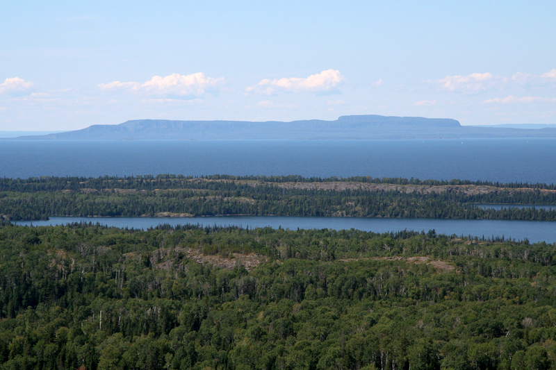
Looking north to Canada from the NE end of Greenstone Ridge
-
hooky

- IR Expert
- Posts: 791
- Joined: Mon Mar 26, 2012 12:26 pm
- Isle Royale Visits: 2
- Location: Central Indiana
Re: Itinerary - Late July to Early August
Ingo's hike would be great for a family with young kids. My son still talks about Moskey and the hike from Daisy Farm to the tower.
If you end up spending time in Rock Harbor, the hike out to Scoville Point is very scenic and worth the time
If you end up spending time in Rock Harbor, the hike out to Scoville Point is very scenic and worth the time
-
Rafiki

- IR Expert
- Posts: 541
- Joined: Thu Apr 08, 2010 12:11 pm
- Isle Royale Visits: 7
- Location: Chicago, IL
Re: Itinerary - Late July to Early August
I agree if you don't mind coming out of the water looking like this, then yes, by all means please swim in the water:McCargo cove beautiful scenic beauty. Darker water, wouldn't be the worst place to swim
[video]http://youtu.be/V4jg8o9wXys?t=11s[/video]
343.1 Miles Hiked: 2004 (3 Days), 2010 (11 Days), 2011 (13 Days), 2012 X 2 (8 + 12 Days), 2013 (9 Days/Paddling), 2019 (30 Days/Paddling)